
SATLANTIS Launches GEISAT Precursor for Methane Detection
Following the successful deployment of its previous satellite almost exactly one year ago, SATLANTIS, the leading global provider of advanced Earth Observation technologies and a resident client at UF Innovate | Accelerate at The Hub, announces its fourth mission, the launch of the GEISAT Precursor satellite. SATLANTIS launched the GEISAT Precursor on June 12th from California. It is a full mission with unique capabilities for both high-resolution visual monitoring and methane emissions tracking (a highly pollutant greenhouse gas), which marks another milestone for the company.
The GEISAT Precursor is the first satellite of the GEISAT Constellation that aims at providing
unprecedented capabilities for CH4 measurements and will include 3 more satellites
under construction today.
GEISAT offers the most accurate pixel size in the market, providing the best technology
to detect the origin of methane emissions with a spatial resolution of up to 13 m
combined with very high-resolution visible imagery of up to 2m, which enables
distinguishing between potential emission sources that may be close to each other.
Additionally, GEISAT builds on the large success of its predecessor, ARMSAT1-URDANETA,
today´s best CubeSat in operation with a 2 m multispectral resolution, thanks to the
SATLANTIS’ proprietary advanced telescope, iSIM-90. These (visible-near infrared)
capacities are equally present in GEISAT but now extending the spectrum towards SWIR
infrared bands.
The GEISAT Precursor traveled in the SpaceX Transporter-8 mission onboard a SpaceX Falcon
9 rocket (a rideshare flight of small satellites to a Sun Synchronous Orbit at a 520 km
distance) from the Space Launch Complex 4E (SLC-4E) at Vandenberg Space Force Base
in California.
The GEISAT Precursor Mission represents an end-to-end solution for methane emissions
detection, point source identification, and quantification. SATLANTIS provides a
comprehensive solution, from the scientific-grade payload to final data products,
enabling accurate and detailed analysis of methane emissions.
Satellite characteristics:
- The satellite is a CubeSat of 16-Unit cube shape, whose sole payload is the iSIM90 optical instrument, a small camera capable of providing high-resolution
images for Earth Observation. One optical channel is dedicated to the visible and
near-infrared spectrum, while the second optical channel is dedicated to the
SWIR (Shortwave Infrared) spectrum. - It offers a spatial resolution of 2 m in the visible and near-infrared bands, and
up to 13 m resolution in SWIR bands for methane detection, with a total of 10
bands (measured from 500 km altitude). The satellite is just 20 centimeters wide
and 40 centimeters high, with deployable solar panels and a total mass of 21 kg.
It is designed to have a nominal lifetime of at least four years of operation.
Key features and added values of the GEISAT Precursor Mission:
- Simultaneous VNIR & SWIR Detection: the satellite measures in both visible and
infrared wavelengths, expanding the spectral capabilities and with optimization
of the SWIR for the detection of methane emissions. - Very High Spatial Resolution: SATLANTIS’ advanced technology enables the
capture of high-resolution images, providing detailed and accurate data for uses
such as methane detection and quantification, agriculture, and forestry. - Agility: unique pointing accuracy, allowing capturing high-quality images
continuously while the satellite observes along and across its orbit, following
non-linear structures on Earth such as pipelines and coastlines. - Environmental Monitoring Solutions: the mission supports E2E environmental
monitoring and contributes to the understanding and mitigation of greenhouse
gas emissions. - The methane End-to-End Solution is turnkey, integrating planning and
acquisition with processing, analysis and reporting.
SATLANTIS, which specializes in high-resolution optical payloads for SmallSats,
has expanded its offerings to include an innovative remote-sensing solution for
detecting and quantifying methane emissions.
With a recent milestone of reaching 100 employees in its offices in Bilbao, Florida, and its recently acquired company SuperSharp, based out in Cambridge (UK), SATLANTIS is building up a
constellation called GEISAT, which will consist of satellites equipped with unprecedented
capabilities for measuring methane (CH4) and other greenhouse gas (GHG) leaks, as well
as the ability to perform visual observation for pipelines, forestry, and coastlines. This
endeavor is being carried out in collaboration with the European Space Agency, the
European Commission, Enagás, and Encino Environmental Services.
During the first month of the mission, the satellite has undergone validation and tuning
of all platform subsystems, the most critical phases being successfully accomplished
during the first days of the in-orbit operation, such as the release of the solar panels and
the antennas, and Sun tracking, the satellite is currently in the LEOP phase.
The next steps involve performing high-speed X-Band downlink measurements, as this
satellite has a radio nearly four times faster than our previous satellite, and instrument
calibration.
The CONSTELLATION
Looking ahead, SATLANTIS plans to grow the GEISAT Constellation consisting of one
additional CubeSat 16U and two MicroSats dedicated to CH4/GHG and the environment.
The satellites are under construction, with a launch calendar between the end of this
year and the end of 2024.
With high spatio-temporal resolution and simultaneous geolocation of emission sources,
these satellites will be instrumental in monitoring and quantifying methane emissions
for the Oil & Gas industry.
CONCLUSION
With the GEISAT Precursor Mission, SATLANTIS continues to lead the way in Earth
Observation technologies, challenging the market towards higher precision
measurements and providing technologies to help solve the pressing requirements for
global methane emissions monitoring, reducing their impact on the environment.
ABOUT SATLANTIS
SATLANTIS is a space company leader in advanced Earth Observation technologies,
providing complete customizable satellite solutions to respond to challenges in various
sectors such as environment and security, among others. Through various space missions
and with its own multispectral and infrared camera technology, it has positioned itself
as a global leader in optical SmallSats, experiencing strong growth in recent years, with
operations in four continents.
SATLANTIS Microsats has its headquarters in Bilbao, SATLANTIS LLC is a sister Company
located in Gainesville (Florida, USA), and SuperSharp, a subsidiary company specialized
in thermal infrared payloads for Earth Observation satellites, is based in Cambridge (UK).
Learn more at https://satlantis.com/
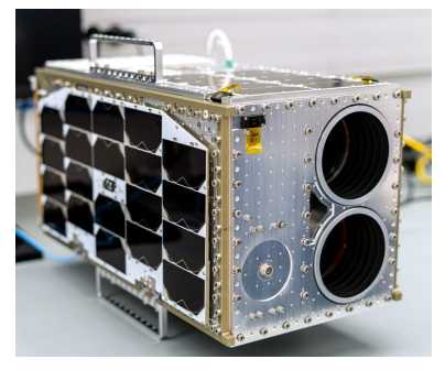
SATLANTIS’ GEISAT Precursor – Photo courtesy of Kongsberg NanoAvionics
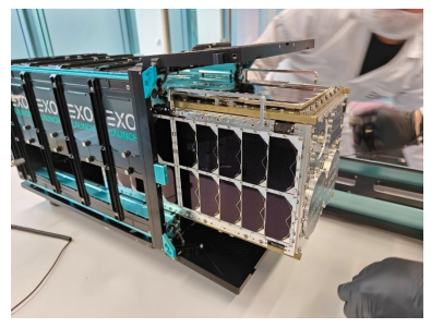
SATLANTIS GEI-SAT Precursor being integrated into the EXOLAUNCH deployer – Photo
courtesy of Exolaunch

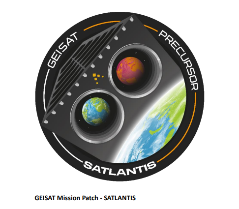
GEISAT Mission Patch – SATLANTIS
- A video of the launch can be found at https://satlantis.com/gei-sat-precursor-launch/ with the deployment of GEISAT at minute 01:12:37.
Contacts:
SATLANTIS Communications Department
Sarah Luise, luise@satlantis.com | Patricia Lasuen, lasuen@satlantis.com